The direct answer
On a Ugandan slope, the structure you build matters less than three decisions you make before building it.
First, measure the slope. Every published specification is written for a slope range, and using a structure outside its range is the most common failure. FAO's water-harvesting contour bunds, for example, are specified for "Slopes: from flat up to 5.0%". They are not a hillside measure, whatever the name suggests.
Second, decide where the water goes. Every cross-slope structure concentrates water. A bund with no safe outlet is a dam that will breach, and the breach usually takes more soil in one storm than the bund saved in a season. FAO is explicit: "The diversion should be connected to a safe outlet, a waterway, a protected area or a storage area."
Third, be honest about labour. FAO's own figure is that "A man can cut and fill 3 to 4 cubic m of earth during eight hours of supervised work." A documented Kenyan farm case recorded construction at "just over 100 days per hectare" and maintenance at "10 person days per hectare" annually. Structures that are not maintained fail, and unmaintained structures are worse than none.
With those three settled, the choice is roughly this:
| Your slope | Start with |
|---|---|
| Under about 5 percent | Grass strips and improved ground cover. Contour bunds if water harvesting is the goal |
| Roughly 5 to 15 percent | Grass strips or soil bunds, on a sourced spacing, with a cut-off drain above and a waterway below |
| Roughly 15 to 50 percent | Soil bunds or fanya juu, allowed to develop into terraces over years, with vegetative stabilisation |
| Roughly 12 to 47 percent, where the labour exists | Hand-built bench terraces, accepting the subsoil problem described below |
| Above roughly 50 percent | Do not cultivate. Convert to permanent cover, trees or grass |
One thing this article will not do is give you a Ugandan design standard, because Falcon could not find one. Every number below is labelled with the country or organisation it came from. That labelling is the most useful thing in this article and you should carry it into any conversation with a supplier or a project.
Who this article is for
Farmers cultivating any sloping land in Uganda, particularly in the south-west, the east and the Rwenzori areas. Extension officers advising them. Programme professionals designing conservation interventions. Students who need to understand why the structures are specified the way they are.
If your interest is trees for soil and water conservation, Falcon's published agroforestry article owns that subject and this one deliberately does not repeat it. The two are complements: this article builds the structure, that one stabilises and extends it.
The problem this solves
Uganda loses measurable quantities of topsoil from its slopes, and the national average conceals the districts where it matters.
A national assessment using the Revised Universal Soil Loss Equation estimated a mean soil-loss risk of 3.2 tonnes per hectare per year across Uganda's erosion-prone land, equivalent to about 62 million tonnes in 2014. It classified about 39% of that land as having estimated losses above 1 tonne per hectare per year. Sixty-six of the 112 districts assessed exceeded that level. Six districts exceeded 10 tonnes per hectare per year, including Bududa at 46.3 and Kasese at 37.5; the estimate for the Rwenzori Mountains protected area was 142.94.
That study is a model, not a set of field measurements, and this article says so. Measured runoff-plot work in the Ugandan highlands puts numbers on the same problem from a different direction: one study reported soil loss under mixed cropping of "7.98 t/ha, 19 t/ha and 25 t/ha at the lower, middle and upper slopes respectively", against a control plot losing "0.094 t/ha, 0.36 t/ha, and 0.54 t/ha" at the same positions, with soil loss "monitored for one growing season". Those are per growing season, not per year, and the study's printed slope classes are ambiguous, so Falcon reports the contrast between cropped and covered ground rather than treating the absolute values as design inputs.
The honest summary is this. Cropped Ugandan slopes lose several tonnes per hectare per season where covered ground loses a fraction of a tonne, and the worst districts are an order of magnitude above the national average. The gap between cropped and covered is the whole argument for these structures.
There is a second dimension. Erosion removes nutrients, not just soil. Work presented to the London Group on environmental accounting, with the Uganda Bureau of Statistics as a project partner, reported 2018 NPK balances by agricultural research zone including minus 138 kilograms per hectare per year at Buginyanya, minus 75 at Nabuin and minus 42 at Ngetta. A field losing soil is a field exporting fertiliser it paid for.
The decision you are making
For one named field, you are deciding:
- The measured slope of that field, in percent.
- Which structure the slope, soil depth and your labour allow.
- The spacing between structures, on a stated rule from a named source.
- Where the concentrated water will go, safely.
- What vegetation will stabilise the structure.
- Who maintains it, and when.
If you cannot answer point 4, do not build.
Uganda-specific context
Three conditions shape what works here.
Rainfall is intense. Structures sized for gentle rain fail. FAO's guidance on spacing water-turning drains, for example, is "mitre drains should be spaced 20 to 250m apart, using the closer intervals where rainfall is heavy". Ugandan rainfall is heavy; use the close end.
Holdings are small. The Uganda Bureau of Statistics Annual Agricultural Survey 2020 reports a national average landholding of 1.2 hectares, an average operated parcel of 0.6 hectares, and about 40 percent of agricultural households holding less than 0.5 hectares. A regional review notes that cross-slope barrier techniques are "associated with the occupation of significant areas of cultivable land". On half a hectare, land taken by a structure is a real cost and must be justified by what it protects.
Adoption is constrained by extension, land and tools, not by ignorance. A survey in Bukwo and Kween on the slopes of Mount Elgon found that "on average, the incidence of technology adoption is appreciably high and the intensity of use is moderately high. Nonetheless, a considerable percentage of farmers are using the technologies on small scale", and that adoption could be increased by "access to extension services, amount of land owned, and diversity of farm tools owned by farmers." Ugandan farmers on slopes generally know erosion is a problem. What limits them is the means to act at scale.
Step 1: measure the slope
Everything depends on this and it can be done with string, two sticks and a spirit level, or with a simple A-frame.
The line level method. Cut two straight sticks of equal length, say 1.5 metres. Stretch a string between them with a line level or a small spirit level hanging on it. Stand one stick downslope of the other, adjust until the string is level, and measure how far up the downslope stick the string sits. That height, divided by the horizontal distance between the sticks, times 100, is the slope percentage.
Convert once and write it down. A slope of 1 metre fall over 10 metres horizontal is 10 percent. Over 20 metres it is 5 percent. Do this in at least three places in the field, because Ugandan fields are rarely uniform, and design for the steepest part.
Then measure soil depth. Dig a pit and find how deep the workable soil goes before you reach hard subsoil or rock. You will need this for the spacing rule below, and it is the number that decides whether terracing is even possible.
Step 2: choose the structure, on evidence
Each option below is given with its source and the region that source was written for. Read the region line. It is doing real work.
Grass strips and vegetative barriers
What they are. Narrow strips of dense perennial grass planted along the contour, which slow runoff, trap sediment and, over years, build a natural terrace as soil accumulates behind them.
Spacing. FAO Soils Bulletin 70 states: "Mark out the contour line (every 5 to 20 m depending on slope and soil depth) by planting perennial grasses." Region: the bulletin's case material is African, with the specific examples drawn from Rwanda and Burkina Faso.
Width. From the Burkina Faso example in the same bulletin, results were achieved "by sowing a 50-cm strip of grass (Andropogon) or a hedge (at least three lines staggered on alternate rows) between two contour ridges (20 cm high)". Region: Burkina Faso, semi-arid, so treat the width as indicative rather than a Ugandan standard.
What they become. The same source describes Rwandan experience where "After some years the microdams (grass strips, hedges, etc.) have produced gradual terraces divided up by steep-sided banks protected by a grass sward", developing on "a 20 to 60% slope over a five-to ten-year period, during which it reaches a maximum height of 1 to 1.5 metres", with terraces forming "primarily through tillage (+ 20 cm in height per year)".
Which grass. A Kenyan trial on clay loam compared narrow strips under 1.5 metres wide, planted at "15 cm within the row", over two seasons. Vetiver reduced runoff by a mean of "12% for the two study periods" and sediment by "48% during the two periods". Napier reduced runoff by a mean of 54 percent and sediment by 92 percent. The authors concluded that "Napier grass was more effective than Vetiver grass in reducing runoff, sediment and nutrient loss."
Read the first-year numbers, not just the means. Vetiver's runoff reduction in the first season was minus 1 percent, rising to 28 percent in the second. Sediment reduction went from 17 percent to 78 percent. A grass strip does almost nothing in its first season and a great deal in its third. Plan for that, and do not judge it in year one.
Why grass strips suit Ugandan smallholdings. Lowest labour, lowest land take, no earthworks, and Napier has a fodder value that pays for the strip. That last point matters: the same feature also creates the biggest risk, covered below.
Soil bunds
What they are. An earth embankment along the contour with a ditch on one side, built to intercept runoff.
Spacing. The Ethiopian national guidelines for development agents give a rule usable anywhere: "The vertical interval between two bunds is two-and-a-half times the depth of soil", and for gentler gradients under 15 percent, "The vertical interval is 1 m for all measures with such slope gradients". Region: Ethiopia, applicable slope range as returned 15 to 50 percent.
That vertical-interval rule is why you measured soil depth. If your workable soil is 40 centimetres deep, the vertical interval is 1 metre, and on a 20 percent slope 1 metre of fall occurs every 5 metres of horizontal distance. That is your spacing.
Falcon could not obtain a bund cross-section table with embankment height and base width from either the FAO or the Ethiopian source, and does not invent one. Ask your district production office or an extension officer for locally used dimensions, and record where the figure came from.
Fanya juu
What it is. A cross-slope structure built by digging a ditch and throwing the soil uphill to form the embankment, rather than downhill. A peer-reviewed review of sub-Saharan cross-slope barriers defines it as "A Kiswahili word referring to 'throw uphill', corresponding to the CSB-SWC structure built by throwing soil upslope from a ditch".
Why throw uphill. Over successive seasons, soil moving downslope accumulates behind the embankment, and the bench forms progressively. The structure builds the terrace for you, using the erosion you are trying to stop.
Where it suits. The same review concludes that "Fanya juu and soil bunds were effective on relatively gentle slopes while hedgerows and stone bunds were effective even on moderately steep slopes." Take that seriously: on genuinely steep ground, vegetative and stone barriers outperformed earth ones in the reviewed evidence.
Spacing. The Ethiopian guidelines apply the same vertical interval rule as for bunds.
Dimensions. Falcon could not open any WOCAT entry and could not obtain a standard fanya juu specification. One documented Kenyan farmer's structures had "channel's dimensions ... (approx) 1.0 m deep and 1.0 - 2.0 m wide; with embankments that are 1.5 m high and spaced at 18 m apart", giving "approximate vertical interval between structures ... 0.9 m", with embankments "stabilized with grass or perennial crops such banana or sugar cane". The report that documents this explicitly states these dimensions are well above standard recommended design, so treat them as one farmer's practice, not as a specification.
Bench terraces
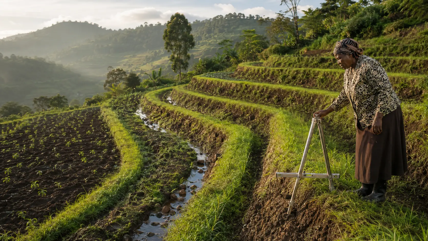
What they are. FAO defines them as "a series of level or virtually level strips running across the slope at vertical intervals, supported by steep banks or risers."
Slope limits. FAO's watershed management field manual gives hand-made bench terraces for "7 to 25 degree (12%-47%) slopes" and machine-built for "7 to 20 degree (12%-36%) slopes". The Ethiopian guidelines extend bench terraces to "Slopes with gradients up to 50%".
Width and risers. FAO: "The optimum width for handmade and manual-cultivated terraces range from 2.5 to 5 m; for machine-built and tractor-cultivated terraces, the range is from 3.5 to 8 m", with riser gradients of "Hand-made with earth material: 0.75:1" and "Hand-made with rocks: 0.5:1".
The problem nobody mentions when selling terracing. FAO states it plainly: "Bench terraces usually expose the infertile subsoil and this can result in lower production unless some prevention or improvement measures are undertaken."
That is not theoretical in Uganda. Measured work on bench terraces in south-western Uganda found that "Crop yield on the upper terrace is much lower than on the more fertile middle and lower sections" and that "clay content decreased from 37.4 to 27.1% between the upper and lower terrace due to erosive transfer during heavy rain and repeated downhill cultivation", on terraces "typically 20 m wide, with a rise of c. 1.5 m between them".
So a newly cut terrace can yield less than the slope it replaced, in the part that was cut. That is a real cost, it is measured in Uganda, and any plan for terracing must include a fertility recovery plan for the upper bench. Falcon's article on composting and the published soil testing article both matter here.
Build them slowly if you can. The Ethiopian guidelines note that bench terraces are "Usually developed from bunds and Fanya Juus over a period of 5-15 years through careful maintenance and buildup". A terrace grown from a bund does not expose subsoil in the same way as one cut in a single season.
Labour. FAO: "A man can cut and fill 3 to 4 cubic m of earth during eight hours of supervised work", rising to "12 to 16 cubic m of dirt moving in an 8-hour period" with animal power.
Step 3: the outlet, which is not optional
This is the section most erosion advice omits and the omission is why structures fail.
Every bund, terrace and strip you build concentrates water somewhere. That water must be led off the field at a velocity the ground can tolerate.
Cut-off drains and diversions above the field
FAO's watershed management manual describes diversions as serving "To protect cultivated lands, roads or farm buildings at the foot of slopes by diverting hillside run-off", with gradients that "can extend to 3%", a freeboard of "10 to 30 cm ... as a safeguard", and length "not exceeding 350 m".
Maximum flow velocities in a diversion, from the same source: "0.4 m/sec for sandy soil, 0.6m/sec for other types of soil" where the channel is bare earth, "1.8 m/sec for average conditions" where it is grass-lined, and "3 m/sec" where it is ballasted.
Cut-off ditches, which intercept subsurface flow, take "A gradient of less than one percent".
And the sentence that governs everything: "The diversion should be connected to a safe outlet, a waterway, a protected area or a storage area."
Waterways below
FAO describes waterways as "channels for receiving and conducting run-off water to a safe or protected area with a minimum of erosion", which "can be parabolic, trapezoidal, rectangular or triangular (V-shaped)".
Permissible velocities: "Grass waterways 1.8 m/sec", "Ballasted stone waterways 3.0 m/sec", "Concrete and masonry waterways 6.0 m/sec", with "A freeboard of 10 to 20 cm ... added for safety purposes".
On the grass itself: "Sod-forming or rhizome grass is preferable to tall bunch-type grass", and it must be "kept as low and as uniform as possible to avoid turbulent flows."
Slope applicability as FAO gives it: grass waterways below 20 percent slope, ballasted below 26 percent, prefabricated concrete chutes above 36 percent.
Maintenance is part of the design. FAO on diversions: "Deposits in the trench or channel must be cleared regularly to ensure that the water flows freely all the time." On waterways: "Any minor breaks in the channels or structures should be repaired immediately."
Falcon does not size channels here. Channel capacity depends on catchment area and local rainfall intensity, which is a calculation for a qualified person with local rainfall data. What this article gives you is the velocity limits that tell you whether your outlet is safe once sized.
Step 4: set out the contour line
The structure is only as good as the line it follows.
- Make an A-frame. Two poles about 2 metres long joined at the top, a crossbar about a third of the way down, and a string with a stone hanging from the apex. Mark the crossbar at the point where the string hangs when both legs are on level ground.
- Calibrate it. Stand it on any ground, mark both leg positions, swap the legs end for end, and mark again. The true level point is halfway between the two string positions. Mark that on the crossbar.
- Walk the contour. Start at one edge of the field. Move one leg, pivot until the string sits on the mark, and peg that position. Repeat across the field. The pegs describe a true contour.
- Smooth the line. Contours wander. Adjust pegs slightly so the line is workable, but never so that it runs downhill.
- Set the next line at the calculated vertical interval, not at a convenient horizontal distance.
- Mark where the water will leave before you dig anything.
Field record: erosion control sheet
One per field, kept with the farm records.
| Item | Entry |
|---|---|
| Field name and area | |
| Slope measured at three points, percent | |
| Steepest measured slope, used for design | |
| Workable soil depth, from a test pit | |
| Structure chosen | |
| Spacing rule used, and the source it came from | |
| Calculated vertical interval and horizontal spacing | |
| Cut-off drain above: yes or no, and its gradient | |
| Outlet: where the water goes, and its lining | |
| Stabilising vegetation planted, species and date | |
| Labour used to construct, person-days | |
| Maintenance date 1, what was done, by whom | |
| Maintenance date 2, what was done, by whom | |
| Condition after the first heavy storm, with the date | |
| Upper bench fertility action taken, if terraced |
The row that predicts failure is maintenance. A regional review found cross-slope barriers reduced runoff by 13 to 71 percent and soil loss by 39 to 83 percent, but those are figures for structures that were maintained.
Costs
Falcon publishes no construction cost. On most Ugandan smallholdings the real currency is labour and land, and both can be estimated from sourced figures.
| Cost category | What sits inside it | Sourced anchor |
|---|---|---|
| Labour, construction | Digging, moving and forming earth | FAO: 3 to 4 cubic metres per person per 8-hour day; 12 to 16 with animal power |
| Labour, maintenance | Annual repair and clearing | Documented Kenyan case: 10 person-days per hectare per year |
| Land take | Ground occupied by the structure and its ditch | A regional review notes cross-slope barriers occupy significant areas of cultivable land |
| Planting material | Grass splits or seed for strips and stabilisation | Local |
| Tools | Hoes, mattocks, an A-frame, string | Extension survey found tool diversity limits adoption |
| Fertility recovery | Organic matter for a cut upper bench | See FF-107 and the published soil testing article |
| Outlet | Waterway forming, grassing or ballasting | Sized by a qualified person |
One documented Kenyan farm case recorded construction at "just over 100 days per hectare". That is a large number and it is why phased, vegetative approaches often beat ambitious earthworks on a smallholding.
Common mistakes
- Building without measuring the slope. Every specification has a slope range and most failures are range violations.
- Using water-harvesting contour bund specifications on a hillside. FAO specifies those for "flat up to 5.0%" and warns they "are not suitable for uneven or eroded land as overtopping of excess water with subsequent breakage may occur at low spots."
- No outlet. The single most destructive mistake. A structure with no safe outlet concentrates water into a breach.
- Spacing by convenience rather than by vertical interval. The interval is set by soil depth and slope, not by how far apart it is comfortable to work.
- Cutting bench terraces in one season on shallow soil. FAO warns that terraces expose infertile subsoil, and Ugandan measurements confirm the yield penalty on the cut upper bench.
- Judging a grass strip in its first year. The Kenyan trial data show first-season performance close to zero and third-season performance high.
- Planting Napier for erosion control and then cutting it hard for fodder. A strip grazed or cut to the ground is not a barrier. Decide which job it is doing.
- Letting livestock onto the structures. Trampling destroys embankments and strips faster than rain.
- Abandoning maintenance after year one. An unmaintained structure concentrates water without controlling it, which is worse than flat cultivation.
- Ignoring the fertility consequence. Erosion control preserves soil. It does not replace the nutrients already gone.
Warning signs and escalation points
| Warning sign | What it means | What to do |
|---|---|---|
| Water flows over the top of a bund rather than along it | The structure is undersized, the line is not level, or there is no outlet | Do not raise it and hope. Re-check the contour line and build the outlet first |
| A gully has started at the end of a structure | The outlet velocity exceeds what the ground tolerates | Stop irrigating or diverting into it. Grass or ballast the channel and get it sized properly |
| Water stands behind a bund for more than a day | Waterlogging, which a regional review names as a documented side effect | Provide controlled drainage. Waterlogging can cost more yield than the erosion did |
| Yields on a newly cut terrace bench are much lower than before | Exposed subsoil, measured in south-western Uganda | Concentrate organic matter on the upper bench. Do not conclude that terracing failed |
| Any structure needs a cut deeper than about waist height | This is engineered earthworks | Stop and engage a qualified surveyor or engineer |
| The slope exceeds roughly 50 percent | Outside the range of every specification quoted here | Do not cultivate it. Convert to permanent cover |
| Cracks, seepage or slumping appear in an embankment after rain | Structural failure beginning | Clear people and animals from below it and get technical advice before the next storm |
| Signs of landslip anywhere on or above the site | A safety matter, not an agronomy matter | Evacuate the area below and report to the district disaster management and environment officers immediately |
When these methods work and when they do not
Grass strips work on almost any cultivated slope, on smallholdings, where labour is scarce and where the grass has a second use. They do not work if the grass is grazed or harvested to the ground, and they do not work in their first season.
Soil bunds and fanya juu work on moderate slopes with adequate soil depth, where labour is available and maintenance is committed. The reviewed evidence found them effective "on relatively gentle slopes" with vegetative and stone barriers doing better on steeper ground.
Bench terraces work where the slope is inside the FAO 12 to 47 percent hand-built range, soil is deep enough, labour is genuinely available, and there is a plan for the exposed upper bench. They do not work on shallow soil, and they do not work as a one-season project on a smallholding.
None of them works above roughly 50 percent slope. At that point the correct answer is not a better structure; it is not cultivating that ground.
And none of them replaces fertility management. A regional review found that more than 80 percent of reviewed studies showed a positive yield effect from cross-slope barriers, but noted that the effect "varies with rainfall and slope, with most of the CSB-SWC techniques improving crop yields in low rainfall areas". Much of Uganda's sloping cropland is not low-rainfall. Do not promise yourself a yield increase from erosion control in a high-rainfall Ugandan highland; promise yourself that you will still have soil.
A low-risk pilot
- Measure and record the slope of one field. Cost: an afternoon and some string.
- Build an A-frame and set out one contour line across that field. Peg it and leave it.
- Plant one grass strip along that line. One strip, one season. This is the cheapest, lowest-risk intervention available and it teaches you the setting-out method.
- Photograph the strip and the ground above and below it, from a fixed point, after every heavy storm. Same spot, same angle, dated.
- Do nothing else for two seasons. Judge the strip in season three, not season one, because the Kenyan trial data show exactly that pattern.
- Only then decide whether to extend to more strips, to convert the strips into bunds, or to move to earthworks.
- Before any earthworks, build the outlet. If you cannot identify a safe outlet, that is the answer to whether you should build the structure.
Limitations and professional-support triggers
What this article does not do. It publishes no Ugandan design standard, because none was located. It gives no bund cross-section dimensions, no channel sizing for any rainfall intensity, no cost, and no promise of a yield increase. It does not cover trees, which the published agroforestry article owns, and it does not cover fertility correction, which the published soil testing article owns.
Provenance warning, stated openly. Every specification here comes from FAO, from Ethiopian national guidelines, from Rwandan and Burkinabè case material in an FAO bulletin, or from a Kenyan trial. Falcon was unable to open any WOCAT technology entry and found no Ugandan design standard. Use these figures as a starting point and confirm locally applicable dimensions with your district production office or a conservation specialist.
Bring in a professional when:
- Your district production office or an extension officer, before building, to confirm locally used dimensions and to see a working example.
- A qualified surveyor or civil engineer, for any cut deeper than about waist height, for channel sizing, and for any structure above or beside a dwelling or road.
- A conservation or watershed specialist, where the field is part of a larger catchment and upstream runoff is the real problem.
- The district disaster management and environment officers, immediately, at any sign of landslip.
- An agronomist and the published soil testing route, to plan fertility recovery on any cut terrace bench.
Clear next actions
- Measure the slope of your steepest cultivated field at three points this week and write the percentages down.
- Dig a test pit and record workable soil depth.
- Use the table in the direct answer to identify which structure your slope range allows.
- Calculate the vertical interval using the two-and-a-half times soil depth rule, and convert it to a horizontal spacing for your slope.
- Walk the field and identify where concentrated water could safely leave. If there is nowhere, solve that first.
- Build an A-frame and set out one contour line.
- Plant one grass strip on it this season.
- Start the erosion control sheet, and photograph the field from a fixed point after the next heavy storm.